
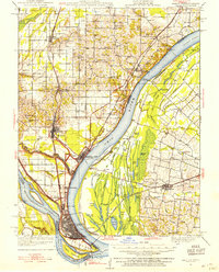
1931 Map of Cairo
USGS Topo · Published 1954About this map
The confluence of the Ohio River and Mississippi River dominates this 1930s landscape, centered on the strategic river town of Cairo. Protected by a system of levees, the city is a dense hub of rail activity, served by major lines including the Illinois Central Railroad and the Mobile and Ohio Railroad. To the north, Mound City and Mounds appear as significant centers of settlement, while the National Cem marks a solemn landmark near the banks of the Ohio River.
Find a feature on this map
118 named features on this map. Tap any name to fly to it.
Don’t see what you’re looking for? This feature index may not catch every label — zoom into the map to look around manually.
Map Details
Editions of this 1931 Cairo Map
2 editions found
Other maps of this area

1918 · Vienna
USGS Topo · 1:62,500

1919 · Vienna
USGS Topo · 1:62,500

1920 · Jonesboro
USGS Topo · 1:62,500

1920 · Dongola
USGS Topo · 1:62,500

1923 · Dongola
USGS Topo · 1:62,500

1923 · Jonesboro
USGS Topo · 1:62,500

1928 · La Center
USGS Topo · 1:62,500

1932 · La Center
USGS Topo · 1:62,500

1933 · Cairo
USGS Topo · 1:62,500

1934 · Thebes
USGS Topo · 1:62,500