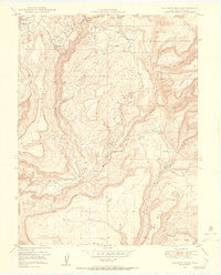
1949 Map of Calamity Mesa
USGS Topo · Published 1955About this map
The United States Atomic Energy Commission collaborated on this 1940s survey, highlighting the industrial importance of this remote section of the Uncompahgre National Forest. The landscape is dominated by the deep incisions of Blue Creek and Calamity Creek, which carve between high plateaus like Calamity Mesa and Outlaw Mesa. The mapping of these canyons and summits was vital during the postwar uranium boom, which is evidenced by the presence of the Hidden Treasure Mine, Small Spot Mine, and the sprawling Blue Creek Mines.
Find a feature on this map
28 named features on this map. Tap any name to fly to it.
Don’t see what you’re looking for? This feature index may not catch every label — zoom into the map to look around manually.
Map Details
Editions of this 1949 Calamity Mesa Map
2 editions found
Other maps of this area

1916 · Paradox Valley
USGS Topo · 1:125,000

1922 · Paradox Valley
USGS Topo · 1:125,000

1948 · Roc Creek
USGS Topo · 1:24,000

1949 · Roc Creek
USGS Topo · 1:24,000

1949 · Juanita Arch
USGS Topo · 1:24,000

1949 · Atkinson Creek
USGS Topo · 1:24,000

1949 · Red Canyon
USGS Topo · 1:24,000

1949 · Calamity Mesa
USGS Topo · 1:24,000

1949 · Gateway
USGS Topo · 1:24,000

1950 · Juanita Arch
USGS Topo · 1:24,000