
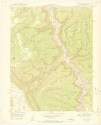
1950 Map of Juanita Arch
USGS Topo · Published 1950About this map
The Dolores River cuts a deep path through the high plateau country of western Colorado in this 1950 survey, which highlights a landscape shaped by both dramatic geology and early atomic-era resource extraction. While the towering sandstone formations like Tenderfoot Mesa and Sewemup Mesa dominate the topography, the map reveals the industrial activity of the period through the Maverick Mines and the Copper Rivet Mine. These remote sites are connected by the winding path of 141, the primary artery through this isolated canyon country. The intricate drainage systems of Salt Creek and Blue Creek illustrate the erosion patterns that created landmarks like the Juanita Arch. Of particular historical interest is the presence of the United States Atomic Energy Commission in the margin, signaling the area's importance during the uranium boom of the mid-twentieth century. Nearby, the enclosed basin of Sinbad Valley provides a distinct geographical contrast to the surrounding canyon walls and high mesas.
Find a feature on this map
18 named features on this map. Tap any name to fly to it.
Don’t see what you’re looking for? This feature index may not catch every label — zoom into the map to look around manually.
Map Details
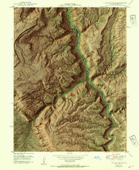
Editions of this 1950 Juanita Arch Map
3 editions found
Other maps of this area

1885 · La Sal
USGS Topo · 1:250,000

1916 · Paradox Valley
USGS Topo · 1:125,000

1922 · Paradox Valley
USGS Topo · 1:125,000

1948 · Roc Creek
USGS Topo · 1:24,000

1949 · Roc Creek
USGS Topo · 1:24,000

1949 · Juanita Arch
USGS Topo · 1:24,000

1949 · Red Canyon
USGS Topo · 1:24,000

1949 · Calamity Mesa
USGS Topo · 1:24,000

1949 · Gateway
USGS Topo · 1:24,000

1950 · Calamity Mesa
USGS Topo · 1:24,000