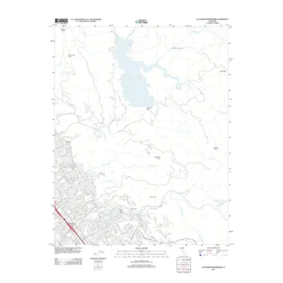
2012 Map of Calaveras Reservoir
USGS Topo · Published 2012About this map
Calaveras Reservoir dominates the northern landscape, its waters contained within a high valley bordered by Oak Ridge and Monument Peak. The terrain is defined by steep ridges and deep drainages, including the Alameda Diversion Tunnel and the winding course of Arroyo Hondo. To the south, the suburban expansion of Berryessa meets the foothills, where the Saint Johns Catholic Cem and numerous residential streets like Yosemite Dr and Piedmont Rd mark the transition from city to mountains. The southeastern corner features the protected lands of Alum Rock Canyon, notable for its geological landmarks like Eagle Rock and the Mineral Springs along Upper Penitencia Cr. This 2012 survey illustrates the sharp boundary between the dense residential development of the Santa Clara Valley and the preserved watershed and wilderness areas of the Diablo Range.
Find a feature on this map
154 named features on this map. Tap any name to fly to it.
Don’t see what you’re looking for? This feature index may not catch every label — zoom into the map to look around manually.
Map Details
Editions of this 2012 Calaveras Reservoir Map
This is the sole edition of this map. No revisions or reprints were ever made.
Other maps of this area

1889 · San Jose
USGS Topo · 1:62,500

1897 · San Jose
USGS Topo · 1:62,500

1897 · Mt. Hamilton
USGS Topo · 1:62,500

1899 · San Jose
USGS Topo · 1:62,500

1906 · Pleasanton
USGS Topo · 1:62,500

1907 · Tesla
USGS Topo · 1:62,500

1941 · Pleasanton
USGS Topo · 1:62,500

1942 · Mt. Hamilton
USGS Topo · 1:62,500

1942 · Altamont
USGS Topo · 1:62,500

1943 · Pleasanton
USGS Topo · 1:62,500