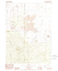
1988 Map of Caldwell Butte
USGS Topo · Published 1988About this map
Lava Beds National Monument Wilderness and the Modoc National Forest define this volcanic environment, where ancient geothermal activity created a landscape of subterranean caverns and cinder cones. The map identifies several prominent geologic features, including Three Sisters, Valentine Cave, and the intriguing Frozen River Cave. Archaeological significance is noted through the presence of Indian Fortifications (Ruins) and additional Indian Fortifications, which indicate the strategic importance of this high-elevation terrain for indigenous peoples. The border between Siskiyou and Modoc counties bisects the region, while resource extraction is evidenced by a Cinder Pit near East Sand Butte and a Gravel Pit to the south. These labels offer a detailed look at the intersection of natural wonders like Caldwell Butte and the physical history of the Modoc War era.
Find a feature on this map
21 named features on this map. Tap any name to fly to it.
Don’t see what you’re looking for? This feature index may not catch every label — zoom into the map to look around manually.
Map Details
Editions of this 1988 Caldwell Butte Map
This is the sole edition of this map. No revisions or reprints were ever made.
Other maps of this area

1886 · Modoc Lava Bed
USGS Topo · 1:250,000

1892 · Modoc Lava-Bed
USGS Topo · 1:250,000

1950 · Mt. Dome
USGS Topo · 1:62,500

1951 · Tulelake
USGS Topo · 1:62,500

1952 · Timber Mountain
USGS Topo · 1:62,500

1952 · Medicine Lake
USGS Topo · 1:62,500

1954 · Alturas
USGS Topo · 1:250,000

1958 · Alturas
USGS Topo · 1:250,000

1962 · Alturas
USGS Topo · 1:250,000

1965 · Alturas
USGS Topo · 1:250,000