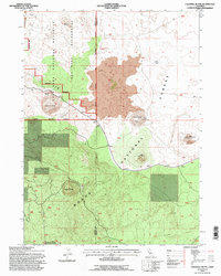
1993 Map of Caldwell Butte
USGS Topo · Published 1996About this map
Lava Beds National Monument dominates this northern California landscape, where the geology of the Siskiyou Co Modoc Co boundary is defined by volcanic features and expansive Lava fields. The map reveals a complex subterranean and surface world, including the notably named Frozen River Cave and various caverns situated within the Lava Beds Wilderness. Cultural history is marked by the presence of Indian Fortifications, offering a window into the indigenous defensive architecture of the region.
Find a feature on this map
21 named features on this map. Tap any name to fly to it.
Don’t see what you’re looking for? This feature index may not catch every label — zoom into the map to look around manually.
Map Details
Editions of this 1993 Caldwell Butte Map
This is the sole edition of this map. No revisions or reprints were ever made.
Other maps of this area

1886 · Modoc Lava Bed
USGS Topo · 1:250,000

1892 · Modoc Lava-Bed
USGS Topo · 1:250,000

1950 · Mt. Dome
USGS Topo · 1:62,500

1951 · Tulelake
USGS Topo · 1:62,500

1952 · Timber Mountain
USGS Topo · 1:62,500

1952 · Medicine Lake
USGS Topo · 1:62,500

1954 · Alturas
USGS Topo · 1:250,000

1958 · Alturas
USGS Topo · 1:250,000

1962 · Alturas
USGS Topo · 1:250,000

1965 · Alturas
USGS Topo · 1:250,000