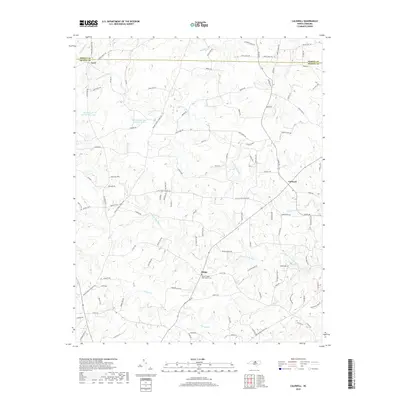
2019 Map of Caldwell
USGS Topo · Published 2019About this map
The boundary between Person and Orange Counties divides this Piedmont landscape, where rural communities and family homesteads are linked by a dense network of country roads. Small settlements like Caldwell and Schley serve as local hubs, with the latter featuring the Payne Chapel AME Church Cem. The terrain is deeply etched by the drainage systems of the North Fork and South Fork Little River, which gather numerous tributaries including Forrest Cr, Byrds Cr, and Rays Cr. This 2019 survey shows a landscape of established farmsteads and growing residential enclaves, evidenced by names like Quiet Acres Dr and Whitetail Run. Water management is visible in the northwest with the presence of Quail Roost Lake Number One and Quail Roost Lake Number Three, while landmarks like the Little River Church anchor the area's social history.
Find a feature on this map
107 named features on this map. Tap any name to fly to it.
Don’t see what you’re looking for? This feature index may not catch every label — zoom into the map to look around manually.
Map Details
Editions of this 2019 Caldwell Map
This is the sole edition of this map. No revisions or reprints were ever made.
Other maps of this area

1943 · Roxboro
USGS Topo · 1:62,500

1951 · Durham North
USGS Topo · 1:62,500

1953 · Greensboro
USGS Topo · 1:250,000

1954 · Greensboro
USGS Topo · 1:250,000

1962 · Greensboro
USGS Topo · 1:250,000

1966 · Greensboro
USGS Topo · 1:250,000

1967 · Cedar Grove
USGS Topo · 1:24,000

1968 · Efland
USGS Topo · 1:24,000
1968 · Hillsborough
USGS Topo · 1:24,000

1968 · Caldwell
USGS Topo · 1:24,000