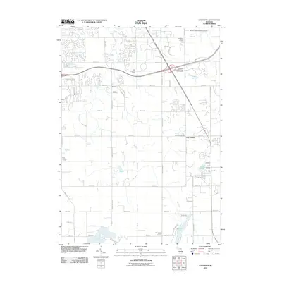
2011 Map of Caledonia
USGS Topo · Published 2011About this map
Gerald R. Ford International Airport anchors the northern landscape of this region, reflecting the modern infrastructure that shapes the suburban expansion near Kentwood. The map captures a moment when traditional agrarian patterns are increasingly interwoven with educational and transportation hubs, notably the Davenport University-WA Lettinga Main Campus. Water remains a central feature, with the terrain draining through Plaster Creek and Pine Hill Creek, while recreational and residential growth is visible around Hanna Lake and Green Lake.
Find a feature on this map
69 named features on this map. Tap any name to fly to it.
Don’t see what you’re looking for? This feature index may not catch every label — zoom into the map to look around manually.
Map Details
Editions of this 2011 Caledonia Map
This is the sole edition of this map. No revisions or reprints were ever made.
Other maps of this area

1914 · Grand Rapids
USGS Topo · 1:62,500

1918 · Lowell
USGS Topo · 1:62,500

1943 · Grand Rapids
USGS Topo · 1:62,500

1943 · Lowell
USGS Topo · 1:62,500

1951 · Hastings
USGS Topo · 1:62,500

1958 · Grand Rapids
USGS Topo · 1:250,000

1959 · Wayland
USGS Topo · 1:62,500

1961 · Grand Rapids
USGS Topo · 1:250,000

1962 · Grand Rapids
USGS Topo · 1:250,000
1967 · Grand Rapids West
USGS Topo · 1:24,000
Featured Places
- Kentwood, MI
- Gaines Charter Township, MI
- Cascade Charter Township, MI
- Caledonia, MI
- Thornapple Township, MI