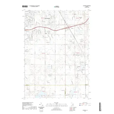
2019 Map of Caledonia
USGS Topo · Published 2019About this map
Kentwood and the neighboring community of Dutton anchor the northern landscape of this survey, where suburban development meets the agricultural reaches of southern Kent County. The map provides a detailed view of the transportation and civic infrastructure serving these communities, most notably the sprawling footprint of the Gerald R Ford International Airport in the northeast. Further south, the village of Caledonia sits near Emmons Lake, surrounded by long-established local landmarks such as Lakeside Cem and Holy Corners.
Find a feature on this map
129 named features on this map. Tap any name to fly to it.
Don’t see what you’re looking for? This feature index may not catch every label — zoom into the map to look around manually.
Map Details
Editions of this 2019 Caledonia Map
This is the sole edition of this map. No revisions or reprints were ever made.
Other maps of this area

1914 · Grand Rapids
USGS Topo · 1:62,500

1918 · Lowell
USGS Topo · 1:62,500

1943 · Grand Rapids
USGS Topo · 1:62,500

1943 · Lowell
USGS Topo · 1:62,500

1951 · Hastings
USGS Topo · 1:62,500

1958 · Grand Rapids
USGS Topo · 1:250,000

1959 · Wayland
USGS Topo · 1:62,500

1961 · Grand Rapids
USGS Topo · 1:250,000

1962 · Grand Rapids
USGS Topo · 1:250,000
1967 · Grand Rapids West
USGS Topo · 1:24,000
Featured Places
- Kentwood, MI
- Gaines Charter Township, MI
- Cascade Charter Township, MI
- Caledonia, MI
- Thornapple Township, MI