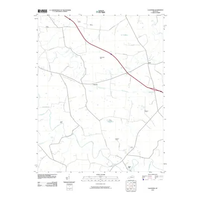
2010 Map of Caledonia
USGS Topo · Published 2010About this map
Caledonia and the nearby settlement of Julien anchor this Kentucky landscape, which is defined by the winding course of the Little River and its numerous tributaries. The map reveals a deeply established agricultural community evidenced by a high density of family and community burial grounds, including the Stapp Cemetery, Northington Cemetery, Nancy Cemetery, and the Old Presbyterian Cemetery. Such a concentration of cemeteries, often situated on high ground or near creek bends like Sinking Fork, provides a clear view of early settlement patterns and family landholdings in Trigg County.
Find a feature on this map
49 named features on this map. Tap any name to fly to it.
Don’t see what you’re looking for? This feature index may not catch every label — zoom into the map to look around manually.
Map Details
Editions of this 2010 Caledonia Map
This is the sole edition of this map. No revisions or reprints were ever made.
Other maps of this area

1950 · Caledonia
USGS Topo · 1:24,000

1951 · Church Hill
USGS Topo · 1:24,000

1951 · Caledonia
USGS Topo · 1:24,000

1951 · Roaring Spring
USGS Topo · 1:24,000

1951 · Johnson Hollow
USGS Topo · 1:24,000

1951 · Herndon
USGS Topo · 1:24,000

1952 · Pleasant Green Hill
USGS Topo · 1:24,000

1953 · Gracey
USGS Topo · 1:24,000

1953 · Cobb
USGS Topo · 1:24,000
1953 · Cadiz
USGS Topo · 1:24,000