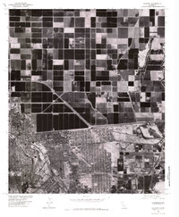
1976 Map of Calexico
USGS Topo · Published 1980About this map
Calexico is captured in sharp detail by this 1976 orthophotograph, illustrating the stark geometric divide between California's intensive agricultural fields and the dense urban grid of the international border. The imagery reveals the massive scale of the All American canal system and the Central Main waterway, which transform the arid Imperial Valley landscape into a productive patchwork of dark, saturated crop fields. To the south, the international boundary with Mexico serves as a sharp line of demarcation, where the concentrated residential patterns of the neighboring city meet the industrial-scale farming of the United States. Along the eastern edge, the Alamo River cuts a narrow path through the irrigated blocks, providing a rare natural curve amidst the strictly surveyed lines of the 20th-century borderlands.
Find a feature on this map
5 named features on this map. Tap any name to fly to it.
Don’t see what you’re looking for? This feature index may not catch every label — zoom into the map to look around manually.
Map Details
Editions of this 1976 Calexico Map
This is the sole edition of this map. No revisions or reprints were ever made.
Other maps of this area

1907 · Holtville
USGS Topo · 1:125,000

1915 · El Centro
USGS Topo · 1:125,000

1940 · Brawley
USGS Topo · 1:62,500

1940 · Heber
USGS Topo · 1:62,500

1940 · Alamorio
USGS Topo · 1:62,500

1940 · Calexico
USGS Topo · 1:62,500

1942 · El Centro
USGS Topo · 1:250,000

1943 · Heber
USGS Topo · 1:62,500

1943 · Brawley
USGS Topo · 1:62,500

1943 · Calexico
USGS Topo · 1:62,500