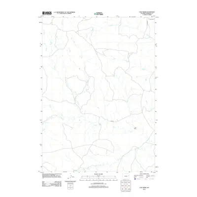
2012 Map of Calf Draw
USGS Topo · Published 2012About this map
Calf Draw defines the central topography of this corner of Niobrara County, where a network of ephemeral drainage channels shapes the rangeland. The map illustrates a high-plains landscape carved by several branches of Cow Creek, including Middle Cr and Little Cow Cr, alongside the northern-flowing Dogie Cr. This hydraulic pattern reveals the essential nature of the eastern Wyoming terrain, where life and transit are dictated by the presence of seasonal water sources and draws. Human presence is marked by a sparse but deliberate network of corridors such as Burke Rd and N Lance Creek Rd, which provide access through the open country. Researchers can trace the varied courses of Bull Cr, W Bull Cr, and Snyder Cr, illustrating the complex watershed that characterizes the region west of the Black Hills.
Find a feature on this map
11 named features on this map. Tap any name to fly to it.
Don’t see what you’re looking for? This feature index may not catch every label — zoom into the map to look around manually.
Map Details
Editions of this 2012 Calf Draw Map
This is the sole edition of this map. No revisions or reprints were ever made.
Other maps of this area

1955 · Newcastle
USGS Topo · 1:250,000

1958 · Newcastle
USGS Topo · 1:250,000

1981 · Calf Draw
USGS Topo · 1:24,000
1981 · Wagonhound Creek
USGS Topo · 1:24,000

1981 · Mercer Draw
USGS Topo · 1:24,000

1981 · Pinnacle Rocks
USGS Topo · 1:24,000

1981 · Dixon Ranch
USGS Topo · 1:24,000

1981 · Lance Creek NW
USGS Topo · 1:24,000

1981 · Garland Draw
USGS Topo · 1:24,000

1981 · Wagonhound Creek NE
USGS Topo · 1:24,000