
1981 Map of Wagonhound Creek NE
USGS Topo · Published 1981About this map
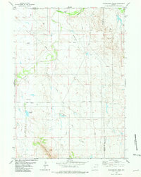
Cheyenne River waters the northern boundary of this high plains landscape at the border of Weston and Niobrara counties. The area is defined by a deep network of drainage draws and seasonal creeks, including Piney Draw, Windmill Draw, and Snyder Creek, which flow toward the more prominent Lance Creek. Energy exploration is the primary human footprint visible in the late 1970s, evidenced by numerous Drill Holes and Oil Wells scattered across the township sections. Transportation is limited to rugged tracks like Lance Road and a solitary Landing Strip, reflecting the isolation of this ranching and mineral-rich territory. The mapping provides a clear record of the intersection between Wyoming's natural topography and the industrial development typical of the region's oil and gas basins.
Find a feature on this map
13 named features on this map. Tap any name to fly to it.
Don’t see what you’re looking for? This feature index may not catch every label — zoom into the map to look around manually.
Map Details
Editions of this 1981 Wagonhound Creek NE Map
This is the sole edition of this map. No revisions or reprints were ever made.
Other maps of this area

1955 · Newcastle
USGS Topo · 1:250,000

1958 · Newcastle
USGS Topo · 1:250,000

1979 · Newcastle
USGS Topo · 1:100,000

1981 · Calf Draw
USGS Topo · 1:24,000
1981 · Wagonhound Creek
USGS Topo · 1:24,000

1981 · Pinnacle Rocks
USGS Topo · 1:24,000

1981 · Dixon Ranch
USGS Topo · 1:24,000

1981 · Garland Draw
USGS Topo · 1:24,000

1981 · Lance Creek
USGS Topo · 1:100,000
1982 · Lion Creek
USGS Topo · 1:24,000