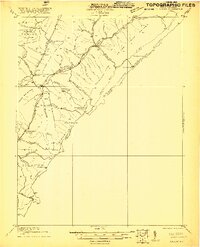
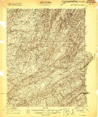
1921 Map of Callaghan
USGS Topo · Published 1921About this map
The mountain gaps and winding valley drafts of the West Virginia Virginia borderlands define this 1921 survey, centered on the Anthony Creek watershed. Small settlements like Neola and Alvon anchor a landscape where education was highly localized, evidenced by a dense network of mountain institutions including Slab Camp School, Bound School, and Allegheny Mt School. The presence of Columbia Sulphur Springs at the northern edge reflects the region's enduring appeal for mineral spring tourism during the early twentieth century.
Find a feature on this map
67 named features on this map. Tap any name to fly to it.
Don’t see what you’re looking for? This feature index may not catch every label — zoom into the map to look around manually.
Map Details
Editions of this 1921 Callaghan Map
This is the sole edition of this map. No revisions or reprints were ever made.
Other maps of this area

1887 · Lewisburg
USGS Topo · 1:125,000

1891 · Lewisburg
USGS Topo · 1:125,000

1891 · Huntersville
USGS Topo · 1:125,000

1894 · Huntersville
USGS Topo · 1:125,000

1894 · Natural Bridge
USGS Topo · 1:125,000

1901 · Monterey
USGS Topo · 1:125,000
1913 · Eagle Rock
USGS Topo · 1:48,000
1915 · Eagle Rock
USGS Topo · 1:62,500
1921 · White Sulphur Springs
USGS Topo · 1:48,000
1921 · Ronceverte
USGS Topo · 1:48,000