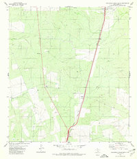
1980 Map of Callaghan Ranch South
USGS Topo · Published 1980About this map
Missouri Pacific railroad tracks dominate the eastern half of this Webb County landscape, connecting the small siding of Botines in the south to Webb and the larger Callaghan Ranch headquarters to the north. This rangeland environment is defined by its water management and transport corridors, where numerous Well and Tank sites are distributed across the drainage basins of Tejones Creek, Tordillo Creek, and Sombrerito Creek. Near the northern boundary, the Castro Cem stands as a quiet marker of early ranching families in the brush country. The map captures a period of modern connectivity, evidenced by several Radio Tower installations and the straight-line path of Highway 83 cutting through the western terrain near Davis. This area illustrates the transition of the South Texas ranching economy as it integrated with regional rail and highway networks during the late twentieth century.
Find a feature on this map
16 named features on this map. Tap any name to fly to it.
Don’t see what you’re looking for? This feature index may not catch every label — zoom into the map to look around manually.
Map Details
Editions of this 1980 Callaghan Ranch South Map
This is the sole edition of this map. No revisions or reprints were ever made.
Other maps of this area

1956 · Las Tiendas
USGS Topo · 1:62,500

1956 · Islitas
USGS Topo · 1:62,500

1956 · Laredo East
USGS Topo · 1:62,500

1956 · Webb
USGS Topo · 1:62,500

1956 · Laredo
USGS Topo · 1:250,000

1965 · Orvil
USGS Topo · 1:24,000

1965 · Spohn Ranch
USGS Topo · 1:24,000

1965 · Cuervo Creek
USGS Topo · 1:24,000

1965 · Cibolo Ranch
USGS Topo · 1:24,000

1965 · Nido Ranch
USGS Topo · 1:24,000