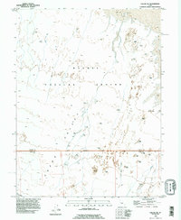
1993 Map of Callao NE
USGS Topo · Published 1996About this map
Pony Express Route traces the southwestern corner of this landscape, marking a historic transit corridor through the desolate expanse of Snake Valley. The map reveals a highly specialized environment dominated by the sprawling Dugway Proving Ground, where the Military Reservation Boundary defines the transition between public lands and restricted military space. This 1993 revision, based on imagery from 1970, captures a terrain of shifting Sand Dunes and expansive Mud Flat areas, punctuated only by the seasonal drainage of Fish Springs Wash. The lack of permanent settlements emphasizes the region's role as a remote testing facility and a corridor for ancient and modern transport routes across the Great Basin.
Find a feature on this map
8 named features on this map. Tap any name to fly to it.
Don’t see what you’re looking for? This feature index may not catch every label — zoom into the map to look around manually.
Map Details
Editions of this 1993 Callao NE Map
This is the sole edition of this map. No revisions or reprints were ever made.
Other maps of this area

1908 · Fish Springs
USGS Topo · 1:250,000

1910 · Fish Springs
USGS Topo · 1:250,000

1953 · Tooele
USGS Topo · 1:250,000

1953 · Delta
USGS Topo · 1:250,000

1955 · Tooele
USGS Topo · 1:250,000

1958 · Delta
USGS Topo · 1:250,000

1962 · Delta
USGS Topo · 1:250,000

1967 · Fish Springs NW
USGS Topo · 1:24,000
1967 · Fish Springs SW
USGS Topo · 1:24,000

1972 · Mud Lake Reservoir
USGS Topo · 1:24,000