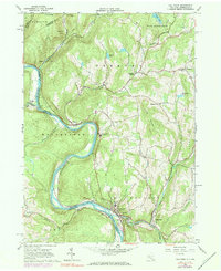
1965 Map of Callicoon
USGS Topo · Published 1984About this map
The Delaware River defines the winding border between New York and Pennsylvania on this mid-1960s topographic record, where the Erie-Lackawanna railroad hugs the shoreline. This riverine landscape is punctuated by steep valley slopes, where prominent ridges like Long Ridge and Cherry Ridge loom over riverside communities. In the village of Callicoon, the St Josephs Seminary and its associated St Josephs Seminary (Cem) stand near the Athletic Field, serving as a cultural and educational anchor for the region. To the north, the smaller settlement of Hankins sits at the confluence of Hankins Creek and the river, while rural hamlets like Mileses and Fremont Center are scattered along the inland brooks. Local industry is evidenced by numerous quarries near Hawks Nest, while the spiritual and community life of the area is mapped through sites like St Marys Ch in Obernburg and Mt Zion Ch near Pleasant Valley.
Find a feature on this map
55 named features on this map. Tap any name to fly to it.
Don’t see what you’re looking for? This feature index may not catch every label — zoom into the map to look around manually.
Map Details
Editions of this 1965 Callicoon Map
Other maps of this area

1920 · Long Eddy
USGS Topo · 1:62,500

1920 · Damascus
USGS Topo · 1:62,500

1921 · Long Eddy
USGS Topo · 1:48,000

1921 · Livingston Manor
USGS Topo · 1:62,500

1922 · White Lake
USGS Topo · 1:62,500

1923 · Damascus
USGS Topo · 1:62,500

1923 · Long Eddy
USGS Topo · 1:62,500

1923 · Livingston Manor
USGS Topo · 1:62,500

1942 · White Lake
USGS Topo · 1:62,500

1943 · Honesdale
USGS Topo · 1:125,000