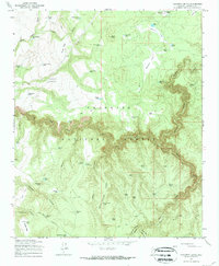
1965 Map of Calloway Butte
USGS Topo · Published 1972About this map
The Coconino National Forest defines this high-altitude landscape of northern Arizona as it appeared in the mid-1960s. The terrain is characterized by a network of drainage features and volcanic formations, notably Calloway Butte and Soldier Mesa in the southwest and Sams Butte to the north. Water management in this arid environment is evident through an extensive system of named catchments, such as Turkey Draw Tank, Snake Ridge Tank, and Dead Horse Tank, which support the region's livestock and wildlife.
Find a feature on this map
63 named features on this map. Tap any name to fly to it.
Don’t see what you’re looking for? This feature index may not catch every label — zoom into the map to look around manually.
Map Details
Editions of this 1965 Calloway Butte Map
3 editions found
Other maps of this area

1887 · Verde
USGS Topo · 1:250,000

1892 · Verde
USGS Topo · 1:250,000

1923 · Camp Verde
USGS Topo · 1:125,000

1929 · Turret Peak
USGS Topo · 1:125,000

1932 · Camp Verde
USGS Topo · 1:125,000

1933 · Turret Peak
USGS Topo · 1:125,000

1934 · Pine
USGS Topo · 1:62,500

1936 · Camp Verde
USGS Topo · 1:125,000

1940 · Pine
USGS Topo · 1:62,500

1952 · Pine
USGS Topo · 1:62,500