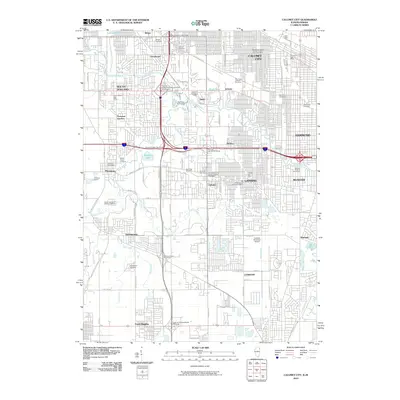
2010 Map of Calumet City
USGS Topo · Published 2010About this map
Thornton Quarry dominates the western landscape of this 2010 survey, serving as a massive industrial anchor near the communities of Thornton and South Holland. The map documents a dense network of suburban development and infrastructure, defined by the heavy presence of the Bishop Ford Freeway and the Tri-State Tollway intersecting at the Calumet-Kingery Interchange. This era shows the mature growth of Calumet City, Lansing, and Hammond, where residential blocks are punctuated by numerous large cemeteries such as Oak Hill Cemetery and Mount Glenwood Memory Gardens. Waterways like the Little Calumet River and Thorn Creek weave through the urban grid, providing a natural contrast to the surrounding municipal structures and the Lansing Municipal Airport. The map is a vital record of the southern Chicago suburbs, illustrating how transportation corridors and industrial sites like Thornton Junction shaped local geography.
Find a feature on this map
66 named features on this map. Tap any name to fly to it.
Don’t see what you’re looking for? This feature index may not catch every label — zoom into the map to look around manually.
Map Details
Editions of this 2010 Calumet City Map
This is the sole edition of this map. No revisions or reprints were ever made.
Other maps of this area

1892 · Calumet
USGS Topo · 1:62,500

1893 · Calumet
USGS Topo · 1:62,500

1900 · Toleston
USGS Topo · 1:62,500

1900 · Calumet
USGS Topo · 1:62,500

1901 · Calumet
USGS Topo · 1:62,500

1929 · Calumet Lake
USGS Topo · 1:24,000

1929 · Calumet City
USGS Topo · 1:24,000
1929 · Blue Island
USGS Topo · 1:24,000

1929 · Harvey
USGS Topo · 1:24,000

1929 · Dyer
USGS Topo · 1:24,000