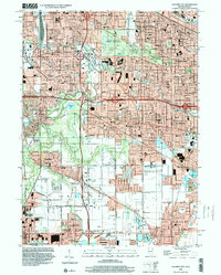
1998 Map of Calumet City
USGS Topo · Published 2000About this map
Calumet City and Lansing anchor this late-century landscape where dense suburban expansion meets the protected woodlands of the Cook County Forest Preserve. The map documents a highly developed corridor along the Illinois Indiana border, defined by a complex intersection of major transit routes including the Tri-State Tollway and the Kingery Expressway. This infrastructure bisects residential neighborhoods and large industrial zones, yet significant green spaces like Lansing Woods and the waters of Wampum Lake remain. Genealogists and local historians will find a dense network of institutional landmarks, from St Margaret Hospital to numerous parochial schools and large burial grounds such as Holy Cross Cemetery and Assumption Cemetery. The presence of the Lansing Municipal Airport and the Grand Trunk Western RR lines underscores the area's continued role as a transportation hub for the south Chicago metropolitan region.
Find a feature on this map
64 named features on this map. Tap any name to fly to it.
Don’t see what you’re looking for? This feature index may not catch every label — zoom into the map to look around manually.
Map Details
Editions of this 1998 Calumet City Map
This is the sole edition of this map. No revisions or reprints were ever made.
Other maps of this area

1892 · Calumet
USGS Topo · 1:62,500

1893 · Calumet
USGS Topo · 1:62,500

1900 · Toleston
USGS Topo · 1:62,500

1900 · Calumet
USGS Topo · 1:62,500

1901 · Calumet
USGS Topo · 1:62,500

1929 · Calumet Lake
USGS Topo · 1:24,000

1929 · Calumet City
USGS Topo · 1:24,000
1929 · Blue Island
USGS Topo · 1:24,000

1929 · Harvey
USGS Topo · 1:24,000

1929 · Dyer
USGS Topo · 1:24,000