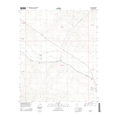
2014 Map of Calva
USGS Topo · Published 2014About this map
The Gila River meanders through the heart of the Gila Valley in this desert landscape, where the settlements of Calva and Bylas serve as the primary hubs of activity. Transportation is dominated by the corridor of Us-70, which runs parallel to the river and provides access across the arid terrain. The map reveals a complex network of seasonal drainages and canyons, including Wildhorse Canyon and Bone Spring Canyon, which feed into the main river system. Local infrastructure is noted by several Bureau of Indian Affairs routes like Bia-99 and Bia-561, which connect the small settlements to the surrounding hills. To the east, Navajo Point stands as a prominent landmark overlooking Bates Draw, while Poison Spring in the northwest indicates the vital, if few, water sources found away from the river bank.
Find a feature on this map
29 named features on this map. Tap any name to fly to it.
Don’t see what you’re looking for? This feature index may not catch every label — zoom into the map to look around manually.
Map Details
Editions of this 2014 Calva Map
This is the sole edition of this map. No revisions or reprints were ever made.
Other maps of this area

1954 · Mesa
USGS Topo · 1:250,000

1957 · Mesa
USGS Topo · 1:250,000

1958 · Mesa
USGS Topo · 1:250,000

1960 · Mesa
USGS Topo · 1:250,000

1960 · Bylas
USGS Topo · 1:62,500

1962 · San Carlos Reservoir
USGS Topo · 1:62,500

1964 · Mesa
USGS Topo · 1:250,000

1966 · Branaman Spring
USGS Topo · 1:24,000
1966 · Ash Creek Ranch
USGS Topo · 1:24,000
1966 · Mount Triplet
USGS Topo · 1:24,000