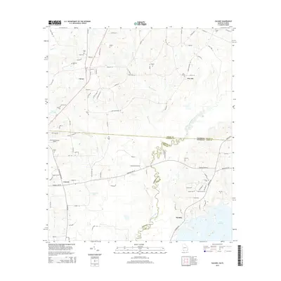
2014 Map of Calvary
USGS Topo · Published 2014About this map
The Ochlockonee River defines a winding border between Georgia and Florida in this 2014 survey, carving through the landscape between Grady, Gadsden, and Leon counties. This rural borderland is anchored by several small communities and historic family-named burial grounds. To the north in Georgia, the settlement of Calvary sits at the junction of Ga-111 and Old 179 S, while Pine Hill and Concord serve as local hubs for the surrounding agricultural tracts. The map details a landscape dominated by drainage systems like Bryants Mill Cr and Shaw Cr that feed toward the river and the large expanse of Lake Iamonia in the south. Aviation history is noted by the Rutten Dusting Strip Airport, pointing to the region's agricultural industry. Genealogists will find a wealth of local landmarks including Higdon Cem, Elkins Cem, and Iamonia Cem, many of which represent family lineages tied to the small settlements and rural roads spanning the state line.
Find a feature on this map
94 named features on this map. Tap any name to fly to it.
Don’t see what you’re looking for? This feature index may not catch every label — zoom into the map to look around manually.
Map Details
Editions of this 2014 Calvary Map
This is the sole edition of this map. No revisions or reprints were ever made.
Other maps of this area

1954 · Tallahassee
USGS Topo · 1:250,000

1955 · Whigham
USGS Topo · 1:62,500

1956 · Havana North
USGS Topo · 1:24,000

1956 · Cairo
USGS Topo · 1:62,500

1956 · Calvary
USGS Topo · 1:24,000

1957 · Beachton
USGS Topo · 1:24,000

1959 · Tallahassee
USGS Topo · 1:250,000

1960 · Tallahassee
USGS Topo · 1:250,000
1963 · Bradfordville
USGS Topo · 1:24,000

1963 · Lake Jackson
USGS Topo · 1:24,000