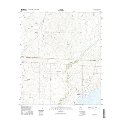
2017 Map of Calvary
USGS Topo · Published 2017About this map
The Ochlockonee River winds through the borderlands of Georgia and Florida, anchoring a landscape defined by small rural settlements and extensive wetland systems. In the north, Calvary serves as a local hub near several family burial grounds, including Higdon Cem and Piedmont Cem. The map illustrates the transition from the upland ridges of Georgia into the lake-strewn basin of Florida, where Lake Iamonia and H.H. Swisher Pond dominate the southern topography. This area is a complex of county lines and survey townships, where Gadsden Co and Leon Co meet along the river’s path. Local infrastructure is sparse, characterized by names like Rutten Airstrip and a network of named trails such as Lower Hawthorne Trl. Genealogists will find a high density of documented cemeteries like Elkins Cem and Barber Cem scattered near the old community of Concord, reflecting the deep-rooted settlement patterns of this interstate corridor.
Find a feature on this map
96 named features on this map. Tap any name to fly to it.
Don’t see what you’re looking for? This feature index may not catch every label — zoom into the map to look around manually.
Map Details
Editions of this 2017 Calvary Map
This is the sole edition of this map. No revisions or reprints were ever made.
Other maps of this area

1954 · Tallahassee
USGS Topo · 1:250,000

1955 · Whigham
USGS Topo · 1:62,500

1956 · Havana North
USGS Topo · 1:24,000

1956 · Cairo
USGS Topo · 1:62,500

1956 · Calvary
USGS Topo · 1:24,000

1957 · Beachton
USGS Topo · 1:24,000

1959 · Tallahassee
USGS Topo · 1:250,000

1960 · Tallahassee
USGS Topo · 1:250,000
1963 · Bradfordville
USGS Topo · 1:24,000

1963 · Lake Jackson
USGS Topo · 1:24,000