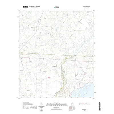
2020 Map of Calvary
USGS Topo · Published 2020About this map
Calvary and the surrounding borderlands of Georgia and Florida are defined by the winding course of the Ochlockonee River, which serves as both a natural boundary and a focal point for the region's geography. The landscape transitions from the upland farming and timber tracts near Concord to the expansive wetlands of Lake Iamonia in the southeast. This contemporary survey reveals a deeply rooted community structure, where numerous family and local cemeteries such as Lamonia Cem, Piedmont Cem, and the Williams Cem Old stand as markers of generational residency along established routes like Meridian Rd. The map detail traces the drainage of Swamp Cr and Shaw Cr, highlighting the importance of water management in this rural corridor. Notable landmarks including the Rutten Airstrip and Pine Hill Church anchor the rural settlement pattern between the small centers of commerce.
Find a feature on this map
100 named features on this map. Tap any name to fly to it.
Don’t see what you’re looking for? This feature index may not catch every label — zoom into the map to look around manually.
Map Details
Editions of this 2020 Calvary Map
This is the sole edition of this map. No revisions or reprints were ever made.
Other maps of this area

1954 · Tallahassee
USGS Topo · 1:250,000

1955 · Whigham
USGS Topo · 1:62,500

1956 · Havana North
USGS Topo · 1:24,000

1956 · Cairo
USGS Topo · 1:62,500

1956 · Calvary
USGS Topo · 1:24,000

1957 · Beachton
USGS Topo · 1:24,000

1959 · Tallahassee
USGS Topo · 1:250,000

1960 · Tallahassee
USGS Topo · 1:250,000
1963 · Bradfordville
USGS Topo · 1:24,000

1963 · Lake Jackson
USGS Topo · 1:24,000