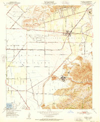
1951 Map of Camarillo
USGS Topo · Published 1951About this map
Camarillo serves as the central hub of this agricultural landscape in the early 1950s, situated at the base of the Camarillo Hills where the Southern Pacific railroad meets Ventura Blvd. The map reveals a highly organized network of drainage and irrigation essential for the Pleasant Valley and Rio de Santa Clara farming districts, including the engineered courses of Calleguas Creek and Revolon Slough. To the southeast, the expansive Camarillo State Hospital complex sits near the foothills of the Santa Monica Mts, while the Camarillo Airport and the nearby St Johns Seminary indicate the town's institutional growth. Smaller settlements and rail sidings like Springville and Leesdale anchor the surrounding fields, alongside named family estates such as Broome Ranch near the southern Naval Res boundary.
Find a feature on this map
39 named features on this map. Tap any name to fly to it.
Don’t see what you’re looking for? This feature index may not catch every label — zoom into the map to look around manually.
Map Details
Editions of this 1951 Camarillo Map
This is the sole edition of this map. No revisions or reprints were ever made.
Other maps of this area

1900 · Triunfo Pass
USGS Topo · 1:62,500

1900 · Piru
USGS Topo · 1:62,500

1903 · Santa Paula
USGS Topo · 1:62,500

1903 · Camulos
USGS Topo · 1:125,000

1904 · Hueneme
USGS Topo · 1:62,500

1921 · Piru
USGS Topo · 1:62,500

1921 · Triunfo Pass
USGS Topo · 1:62,500

1941 · Piru
USGS Topo · 1:62,500

1942 · Santa Paula
USGS Topo · 1:62,500

1942 · Hueneme
USGS Topo · 1:62,500