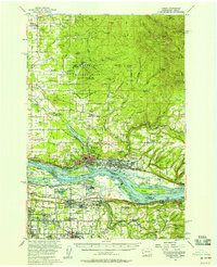
1954 Map of Camas
USGS Topo · Published 1958About this map
The Columbia River serves as the focal point of this mid-1950s survey, marking the interstate border between Clark County, Washington, and Multnomah County, Oregon. On the northern shore, the industrial centers of Camas and Washougal are depicted alongside an Aluminum Plant and the extensive Camp Bonneville Military Reservation. To the south, the expansion of the Portland metropolitan area is evident in the development of Troutdale, Gresham, and Wood Village, connected by the Banfield Expressway and the Union Pacific railroad line.
Find a feature on this map
98 named features on this map. Tap any name to fly to it.
Don’t see what you’re looking for? This feature index may not catch every label — zoom into the map to look around manually.
Map Details
Editions of this 1954 Camas Map
Other maps of this area

1897 · Portland
USGS Topo · 1:62,500

1905 · Portland
USGS Topo · 1:62,500

1911 · Boring
USGS Topo · 1:48,000

1914 · Boring
USGS Topo · 1:62,500

1914 · Oregon City
USGS Topo · 1:62,500

1916 · Estacada
USGS Topo · 1:125,000

1918 · Troutdale
USGS Topo · 1:62,500

1934 · Troutdale
USGS Topo · 1:48,000

1939 · Oregon City
USGS Topo · 1:62,500

1940 · Lookout Mtn
USGS Topo · 1:62,500