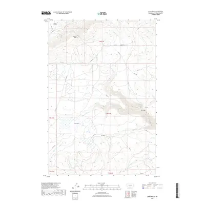
2020 Map of Camas Patch
USGS Topo · Published 2020About this map
Camas Patch sits at the heart of this high-elevation terrain within the Yakima Nation lands, where a complex network of seasonal drainages defines the landscape. The geography is characterized by prominent ridges and deep incisions, notably Toppenish Ridge in the north and the dramatic Wall Canyon to the east. Water management and natural flow are central to the area's character, evidenced by the convergence of the N Fork Dry Cr, Middle Fork Dry Cr, and S Fork Dry Cr. This 2020 survey captures a region primarily organized around Bureau of Indian Affairs transit routes, such as Bia RD 144 and Bia RD 172, which navigate between descriptive landmarks like Whiskey Jim Flat and Starvation Flats. The presence of Dry Creek Falls suggests the abrupt changes in elevation that dictate the local hydrology.
Find a feature on this map
31 named features on this map. Tap any name to fly to it.
Don’t see what you’re looking for? This feature index may not catch every label — zoom into the map to look around manually.
Map Details
Editions of this 2020 Camas Patch Map
This is the sole edition of this map. No revisions or reprints were ever made.
Other maps of this area

1937 · White Swan
USGS Topo · 1:125,000

1950 · Yakima
USGS Topo · 1:250,000
1957 · Willy Dick Canyon
USGS Topo · 1:24,000

1958 · Toppenish Mtn.
USGS Topo · 1:24,000

1958 · Fort Simcoe
USGS Topo · 1:24,000

1958 · Fort Simcoe
USGS Topo · 1:62,500

1958 · Yakima
USGS Topo · 1:250,000

1961 · Yakima
USGS Topo · 1:250,000
1965 · Logy Creek
USGS Topo · 1:62,500
1965 · Logy Creek SW
USGS Topo · 1:24,000