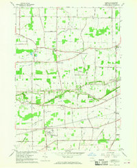
1965 Map of Cambria
USGS Topo · Published 1968About this map
The Lockport Air Force Station and adjacent US Mil Res dominate the central landscape of this Niagara County interior, reflecting the military's footprint during the mid-1960s. The terrain is structured by a series of prominent east-west corridors, most notably Mountain Road and the New York Central Railroad which converges at Lockport Junction. Rural life centers on a network of family-named intersections such as Molyneaux Corners and Streeters Corners, while local heritage is anchored by sites like St Peters Ch and the North Ridge Cem. Significant natural features include the winding Twelvemile Creek Branch and Bull Creek, which drain the agricultural land between the established settlements of Cambria Center and Hickory Corners. The map reveals a transition from traditional farming to specialized land use, evidenced by scattered Sandpits and the Starpoint Central Sch campus.
Find a feature on this map
75 named features on this map. Tap any name to fly to it.
Don’t see what you’re looking for? This feature index may not catch every label — zoom into the map to look around manually.
Map Details
Editions of this 1965 Cambria Map
This is the sole edition of this map. No revisions or reprints were ever made.
Other maps of this area

1894 · Wilson
USGS Topo · 1:62,500

1897 · Tonawanda
USGS Topo · 1:62,500

1897 · Olcott
USGS Topo · 1:62,500

1897 · Lockport
USGS Topo · 1:62,500

1899 · Niagara
USGS Topo · 1:125,000

1900 · Wilson
USGS Topo · 1:62,500

1900 · Tonawanda
USGS Topo · 1:62,500

1901 · Tonawanda
USGS Topo · 1:62,500

1902 · Lockport
USGS Topo · 1:62,500

1905 · Lockport
USGS Topo · 1:62,500