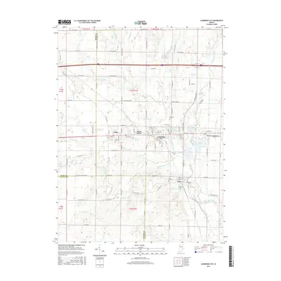
2016 Map of Cambridge City
USGS Topo · Published 2016About this map
Cambridge City and the surrounding townships in Wayne County reveal a dense network of historical settlements along the upper Whitewater River. This modern survey details the close-set community cluster of Dublin, Mount Auburn, and East Germantown, illustrating how the region's development was historically tied to the valley floor. Genealogists can locate several local burial grounds, including the Riverside Cem near the riverbanks and the Friends Cem outside Milton. The landscape is characterized by a series of small, named tributaries such as Symonds Creek, Martindale Creek, and Coon Cr that feed into the river system. Notable water features like Hi-Way Springs and We-Hi Lake provide further context to the local geography. The map also clearly delineates the boundaries where Henry, Fayette, and Wayne counties meet, showing the intersection of rural roads and historical property lines.
Find a feature on this map
86 named features on this map. Tap any name to fly to it.
Don’t see what you’re looking for? This feature index may not catch every label — zoom into the map to look around manually.
Map Details
Editions of this 2016 Cambridge City Map
This is the sole edition of this map. No revisions or reprints were ever made.
Other maps of this area

1948 · Lewisville
USGS Topo · 1:24,000

1950 · New Castle East
USGS Topo · 1:24,000

1950 · Lewisville
USGS Topo · 1:24,000

1953 · Cincinnati
USGS Topo · 1:250,000

1956 · Brownsville
USGS Topo · 1:24,000

1956 · Connersville
USGS Topo · 1:24,000

1957 · Cincinnati
USGS Topo · 1:250,000

1959 · Falmouth
USGS Topo · 1:24,000

1960 · New Castle East
USGS Topo · 1:24,000
1960 · Hagerstown
USGS Topo · 1:24,000