
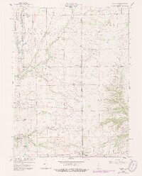
1959 Map of Falmouth
USGS Topo · Published 1960About this map
The Flatrock River winds through the northwestern corner of this landscape, defining the rural character of Rush and Fayette counties during the late 1950s. Small agricultural hubs like Raleigh, Falmouth, and Fairview are connected by a network of drainage systems including Wikoff Ditch and Lawless Ditch, which were vital for managing the fertile plains. The Pennsylvania Railroad cuts diagonally across the northern townships, while an Old Railroad Grade in the south provides a window into an earlier era of transportation. Family and community history is anchored by sites such as the Township Sch near Raleigh and the Hinchman Cem further south. The presence of the Manning Valley Camp and a Gas Well suggests a mix of recreational use and localized natural resource extraction typical of mid-century Indiana.
Find a feature on this map
40 named features on this map. Tap any name to fly to it.
Don’t see what you’re looking for? This feature index may not catch every label — zoom into the map to look around manually.
Map Details
Editions of this 1959 Falmouth Map
2 editions found
Other maps of this area

1948 · Lewisville
USGS Topo · 1:24,000

1950 · Dunreith
USGS Topo · 1:24,000

1950 · Lewisville
USGS Topo · 1:24,000

1953 · Cincinnati
USGS Topo · 1:250,000

1956 · Alpine
USGS Topo · 1:24,000

1956 · Connersville
USGS Topo · 1:24,000

1957 · Cincinnati
USGS Topo · 1:250,000

1959 · Rushville
USGS Topo · 1:24,000

1959 · New Salem
USGS Topo · 1:24,000

1959 · Mays
USGS Topo · 1:24,000