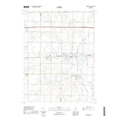
2019 Map of Cambridge City
USGS Topo · Published 2019About this map
Cambridge City and its neighboring villages serve as a focal point for the Whitewater River valley in this contemporary topographic record. The landscape is defined by its historic grid of towns, including Dublin, Milton, and East Germantown, many of which were established as vital stops along the early National Road. Local history and genealogy are preserved through numerous burial grounds such as Riverside Cem, South Lawn Cem, and Capitol Hill Cem. The rural outskirts are marked by a network of drainage runs and creeks like Symonds Creek and Martindale Creek, while transportation remains anchored by CSX Transportation rail lines. A unique point of interest is Milford Friends Cem, reflecting the area's Quaker heritage near the Milton settlement. The convergence of Wayne County, Henry County, and Fayette County borders illustrates the complex local jurisdictional boundaries that have shaped the region's development for over a century.
Find a feature on this map
86 named features on this map. Tap any name to fly to it.
Don’t see what you’re looking for? This feature index may not catch every label — zoom into the map to look around manually.
Map Details
Editions of this 2019 Cambridge City Map
This is the sole edition of this map. No revisions or reprints were ever made.
Other maps of this area

1948 · Lewisville
USGS Topo · 1:24,000

1950 · New Castle East
USGS Topo · 1:24,000

1950 · Lewisville
USGS Topo · 1:24,000

1953 · Cincinnati
USGS Topo · 1:250,000

1956 · Brownsville
USGS Topo · 1:24,000

1956 · Connersville
USGS Topo · 1:24,000

1957 · Cincinnati
USGS Topo · 1:250,000

1959 · Falmouth
USGS Topo · 1:24,000

1960 · New Castle East
USGS Topo · 1:24,000
1960 · Hagerstown
USGS Topo · 1:24,000