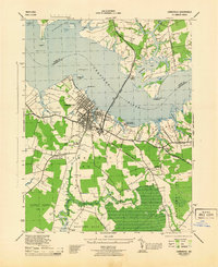
1944 Map of Cambridge
USGS Topo · Published 1944About this map
The Choptank River dominates this 1944 survey, framing the bustling port of Cambridge and its surrounding agricultural and marshy districts. The map documents a significant era of regional infrastructure, showing the Cambridge Branch railroad terminus and the extensive grounds of the Eastern Shore State Hospital along Shoal Creek. Small, established communities like Christs Rock, Thompson, and Mt Holly are clearly defined, often centered around institutions such as the Cardtown Church and Sch. To the south, the landscape transitions from the developed streets of the city to the dense wetlands of the Blackwater River and Little Blackwater River. This detailed view of Cambridge No 7 and its neighbors provides researchers with the locations of family cemeteries like Greenlawn Cem and Bethel Cem, alongside vital maritime aids including Hambrooks Bar Lt and Chancellor Pt Lt.
Find a feature on this map
44 named features on this map. Tap any name to fly to it.
Don’t see what you’re looking for? This feature index may not catch every label — zoom into the map to look around manually.
Map Details
Editions of this 1944 Cambridge Map
This is the sole edition of this map. No revisions or reprints were ever made.
Other maps of this area

1898 · Choptank
USGS Topo · 1:125,000

1898 · St. Marys
USGS Topo · 1:125,000

1903 · Nanticoke
USGS Topo · 1:62,500

1904 · Oxford
USGS Topo · 1:62,500

1905 · Crapo
USGS Topo · 1:62,500

1905 · Hurlock
USGS Topo · 1:62,500

1906 · St. Marys
USGS Topo · 1:125,000

1908 · Choptank
USGS Topo · 1:125,000

1942 · Oxford
USGS Topo · 1:31,680

1942 · Church Creek
USGS Topo · 1:24,000