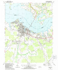
1988 Map of Cambridge
USGS Topo · Published 1988About this map
Cambridge sits at the heart of this survey, where the wide Choptank River separates Dorchester and Talbot Counties. The city's waterfront is defined by a dense concentration of maritime and civic infrastructure, from the Tidal Sta and Kirby Wharf to the sprawling Eastern Shore Hospital Center. Moving inland, the map captures the community's educational and social fabric during the late 1980s, noting institutions such as Chesapeake College and Maces Lane Middle Sch.
Find a feature on this map
81 named features on this map. Tap any name to fly to it.
Don’t see what you’re looking for? This feature index may not catch every label — zoom into the map to look around manually.
Map Details
Editions of this 1988 Cambridge Map
This is the sole edition of this map. No revisions or reprints were ever made.
Other maps of this area

1898 · Choptank
USGS Topo · 1:125,000

1898 · St. Marys
USGS Topo · 1:125,000

1903 · Nanticoke
USGS Topo · 1:62,500

1904 · Oxford
USGS Topo · 1:62,500

1905 · Crapo
USGS Topo · 1:62,500

1905 · Hurlock
USGS Topo · 1:62,500

1906 · St. Marys
USGS Topo · 1:125,000

1908 · Choptank
USGS Topo · 1:125,000

1942 · Oxford
USGS Topo · 1:31,680

1942 · Church Creek
USGS Topo · 1:24,000