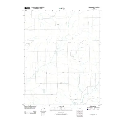
2010 Map of Cambridge NW
USGS Topo · Published 2010About this map
Wingate occupies a quiet corner of Butler County where the landscape is defined by the branching tributaries of the Walnut River watershed. This early 21st-century survey reveals a rural territory organized by an exacting section-line road grid, yet the natural drainage patterns of Timber Creek, Goose Creek, and Grouse Creek frequently disrupt the symmetry of the fields. For family historians, the map identifies local landmarks such as Timber Creek Cemetery and Mount Vernon Cemetery, which serve as physical anchors for the area's agricultural community. The presence of the Grouse Creek Oil Field and Box Oil Field points to the continued significance of petroleum extraction in this region of Kansas. This transition between open pasture and industrial sites like Box Oil Field illustrates the dual nature of the local economy, where traditional land use coexists with modern energy resource management.
Find a feature on this map
28 named features on this map. Tap any name to fly to it.
Don’t see what you’re looking for? This feature index may not catch every label — zoom into the map to look around manually.
Map Details
Editions of this 2010 Cambridge NW Map
This is the sole edition of this map. No revisions or reprints were ever made.
Other maps of this area

1888 · Eldorado
USGS Topo · 1:125,000

1889 · Burden
USGS Topo · 1:125,000

1955 · Wichita
USGS Topo · 1:250,000

1958 · Wichita
USGS Topo · 1:250,000

1962 · Grand Summit
USGS Topo · 1:24,000

1962 · Cambridge
USGS Topo · 1:24,000

1964 · Augusta SE
USGS Topo · 1:24,000

1964 · Latham
USGS Topo · 1:24,000

1964 · Cambridge NW
USGS Topo · 1:24,000
1964 · Cambridge NE
USGS Topo · 1:24,000