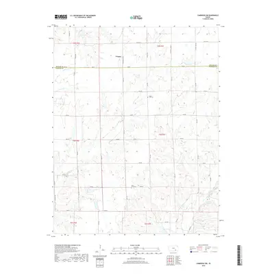
2018 Map of Cambridge NW
USGS Topo · Published 2018About this map
Wingate sits near the northern boundary of this rural landscape, situated just above the Butler Co and Cowley Co line. The terrain is defined by a dense network of watercourses, including the westward-flowing Upper Dutch Cr and Lower Dutch Cr, which eventually give way to the winding paths of Timber Cr and Goose Cr. This 2018 survey illustrates a highly structured grid of section-line roads, such as SE Munson Hill Rd and 281st Rd, that facilitate travel through the agricultural divisions. Small-scale local history is preserved at the Timber Creek Cem and Mount Vernon Cem, providing fixed points of reference for genealogical research. The map also records several smaller drainages like Gardners Br, which contribute to the complex watershed that characterizes this part of the Flint Hills region.
Find a feature on this map
45 named features on this map. Tap any name to fly to it.
Don’t see what you’re looking for? This feature index may not catch every label — zoom into the map to look around manually.
Map Details
Editions of this 2018 Cambridge NW Map
This is the sole edition of this map. No revisions or reprints were ever made.
Other maps of this area

1888 · Eldorado
USGS Topo · 1:125,000

1889 · Burden
USGS Topo · 1:125,000

1955 · Wichita
USGS Topo · 1:250,000

1958 · Wichita
USGS Topo · 1:250,000

1962 · Grand Summit
USGS Topo · 1:24,000

1962 · Cambridge
USGS Topo · 1:24,000

1964 · Augusta SE
USGS Topo · 1:24,000

1964 · Latham
USGS Topo · 1:24,000

1964 · Cambridge NW
USGS Topo · 1:24,000
1964 · Cambridge NE
USGS Topo · 1:24,000