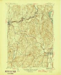
1946 Map of Cambridge
USGS Topo · Published 1946About this map
Batten Kill snakes across this mid-century landscape, providing a geographical anchor for the industrial and agricultural corridors of southern Washington County. The river facilitates the growth of settlements like Battenville and Center Falls, while the Greenwich and Johnsonville RR follows its northern banks. To the south, the village of Cambridge serves as a local hub, home to the Mary McClellan Hospital and the sprawling Woodland Cem.
Find a feature on this map
38 named features on this map. Tap any name to fly to it.
Don’t see what you’re looking for? This feature index may not catch every label — zoom into the map to look around manually.
Map Details
Editions of this 1946 Cambridge Map
2 editions found
Other maps of this area

1893 · Cohoes
USGS Topo · 1:62,500

1895 · Cohoes
USGS Topo · 1:62,500

1895 · Cambridge
USGS Topo · 1:62,500

1897 · Hoosick
USGS Topo · 1:62,500

1898 · Cambridge
USGS Topo · 1:62,500

1898 · Cohoes
USGS Topo · 1:62,500

1900 · Taconic
USGS Topo · 1:125,000

1900 · Schuylerville
USGS Topo · 1:62,500

1901 · Cambridge
USGS Topo · 1:62,500

1903 · Mettawee
USGS Topo · 1:125,000