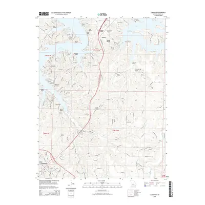
2015 Map of Camdenton
USGS Topo · Published 2015About this map
Lake of the Ozarks dominates the northern reaches of this Missouri landscape, with its irregular shoreline creating a series of deep inlets and points including Linn Creek Bend. The terrain is defined by a dense network of hollows, such as Wildcat Hollow and Shoop Hollow, which drain into the main reservoir and its tributaries like Blue Springs Br. This map illustrates the transition from the lakeside resort and transportation nodes of Osage Beach and Damsel to the inland county seat at Camdenton. The geography shows how modern infrastructure, including the Grand Glaize-Osage Beach Airport and the expansion of US Highway 54, has shaped the area. Local history is preserved in numerous family and community burial grounds, including the Old Erie Cemetery and Zion Cemetery, while the presence of the Coll of the Ozarks marks the area's educational development.
Find a feature on this map
172 named features on this map. Tap any name to fly to it.
Don’t see what you’re looking for? This feature index may not catch every label — zoom into the map to look around manually.
Map Details
Editions of this 2015 Camdenton Map
This is the sole edition of this map. No revisions or reprints were ever made.
Other maps of this area

1888 · Versailles
USGS Topo · 1:125,000

1893 · Versailles
USGS Topo · 1:125,000

1932 · Versailles No 4
USGS Topo · 1:48,000

1933 · Stoutland
USGS Topo · 1:62,500

1934 · Macks Creek
USGS Topo · 1:48,000

1934 · Camdenton
USGS Topo · 1:24,000

1934 · Purvis
USGS Topo · 1:24,000

1934 · Toronto
USGS Topo · 1:24,000

1934 · Lake Ozark
USGS Topo · 1:24,000

1934 · Bagnell
USGS Topo · 1:24,000