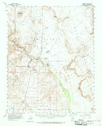
1955 Map of Cameron
USGS Topo · Published 1970About this map
Buck Rodgers Trading Post and the settlement of Cameron anchor this mid-century survey of the Navajo Indian Reservation. The landscape is dominated by the deep incisions of the Little Colorado River Gorge and the stark expanse of the Painted Desert to the east. Transportation through this high desert region relies on the Navahopi Road and the ancient Hopi Trail, while seasonal water sources like Tappan Spring and Janus Spring provide critical relief in the arid terrain.
Find a feature on this map
23 named features on this map. Tap any name to fly to it.
Don’t see what you’re looking for? This feature index may not catch every label — zoom into the map to look around manually.
Map Details
Editions of this 1955 Cameron Map
2 editions found

Other maps of this area

1886 · San Francisco Mtns
USGS Topo · 1:250,000

1886 · Echo Cliffs
USGS Topo · 1:250,000

1891 · San Francisco Mtns
USGS Topo · 1:250,000

1891 · Echo Cliffs
USGS Topo · 1:250,000

1894 · San Francisco Mtns
USGS Topo · 1:250,000

1899 · San Francisco Mtns
USGS Topo · 1:250,000

1947 · Flagstaff
USGS Topo · 1:250,000

1954 · Flagstaff
USGS Topo · 1:250,000

1955 · Black Falls NE
USGS Topo · 1:24,000

1955 · Coconino Pt SE
USGS Topo · 1:24,000