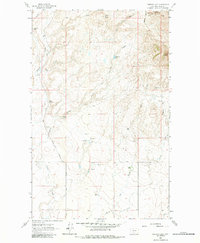
1962 Map of Cameron Lake
USGS Topo · Published 1984About this map
The high plains of Toole County are defined here by a network of seasonal drainages and livestock operations during the early 1960s. Old Berthelote Ranch and Wood Ranch anchor the northern landscape, while the Scalese Ranch and Ride Ranch are situated further south, illustrating the spread of ranching interests across this arid terrain. The map captures the resource-driven character of the region, featuring a Gold Butte Placer Mine at the base of Gold Butte, alongside scattered energy infrastructure including an Oil Well and a Gas Well.
Find a feature on this map
25 named features on this map. Tap any name to fly to it.
Don’t see what you’re looking for? This feature index may not catch every label — zoom into the map to look around manually.
Map Details
Editions of this 1962 Cameron Lake Map
2 editions found
Other maps of this area

1943 · Antelope Coulee
USGS Topo · 1:62,500

1945 · West Butte
USGS Topo · 1:62,500

1954 · Shelby
USGS Topo · 1:250,000

1958 · Shelby
USGS Topo · 1:250,000

1962 · Whitlash
USGS Topo · 1:24,000

1962 · Cameron Lake
USGS Topo · 1:24,000

1962 · Hawthorne School
USGS Topo · 1:24,000

1962 · Berkholder Reservoir
USGS Topo · 1:24,000

1962 · Fey Lakes
USGS Topo · 1:24,000

1962 · Grassy Butte
USGS Topo · 1:24,000