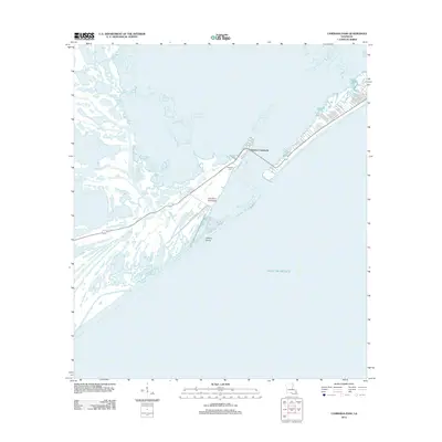
2012 Map of Caminada Pass
USGS Topo · Published 2012About this map
Cheniere Caminada and the surrounding marshlands of Jefferson Parish illustrate a landscape defined by the shifting interface of land and water. This coastal area is intersected by a complex network of waterways, including Bayou Thunder Von Tranc, Bayou Palourde, and Bayou Ferblanc, which navigate the wetlands leading toward the Gulf of Mexico. The map details the residential footprint of the community, where many streets are named for local flora, such as Cherry Ln, Peach Ln, and Fig Ln. Cultural history is anchored by the Cheniere Cem and the geography of Elmers Island, reflecting the persistent human presence on these narrow ridges of land known as cheniers. The infrastructure, including Pump Station Rd and Faa Rd, speaks to the ongoing management of this sensitive alluvial environment in the early 21st century.
Find a feature on this map
27 named features on this map. Tap any name to fly to it.
Don’t see what you’re looking for? This feature index may not catch every label — zoom into the map to look around manually.
Map Details
Editions of this 2012 Caminada Pass Map
This is the sole edition of this map. No revisions or reprints were ever made.
Other maps of this area

1892 · Cheniere Caminada
USGS Topo · 1:62,500

1892 · Creole
USGS Topo · 1:62,500

1893 · Fort Livingston
USGS Topo · 1:62,500

1935 · Mink Bayou
USGS Topo · 1:31,680

1935 · Leeville
USGS Topo · 1:31,680

1945 · New Orleans
USGS Topo · 1:250,000

1945 · Leeville
USGS Topo · 1:31,680
1946 · Mink Bayou
USGS Topo · 1:31,680

1947 · Caminada Pass
USGS Topo · 1:31,680
1948 · Fort Livingston
USGS Topo · 1:62,500