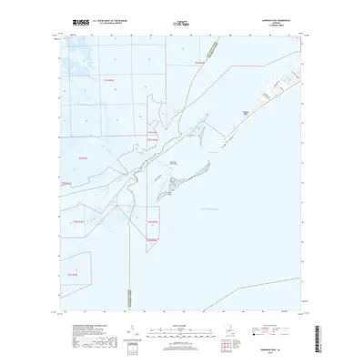
2018 Map of Caminada Pass
USGS Topo · Published 2018About this map
Grand Isle and the adjacent barrier landscape of Cheniere Caminada define this coastal reach where the Gulf of Mexico meets the intricate wetlands of the Mississippi Delta. The map details a landscape dominated by water, from the broad Caminada Pass to smaller tidal channels like Bayou Thunder von Tranc and Bayou Palourde. The parish boundary between Lafourche Parish and Jefferson Parish cuts through these marshes, marking a political division in an area otherwise unified by its maritime character.
Find a feature on this map
27 named features on this map. Tap any name to fly to it.
Don’t see what you’re looking for? This feature index may not catch every label — zoom into the map to look around manually.
Map Details
Editions of this 2018 Caminada Pass Map
This is the sole edition of this map. No revisions or reprints were ever made.
Other maps of this area

1892 · Cheniere Caminada
USGS Topo · 1:62,500

1892 · Creole
USGS Topo · 1:62,500

1893 · Fort Livingston
USGS Topo · 1:62,500

1935 · Mink Bayou
USGS Topo · 1:31,680

1935 · Leeville
USGS Topo · 1:31,680

1945 · New Orleans
USGS Topo · 1:250,000

1945 · Leeville
USGS Topo · 1:31,680
1946 · Mink Bayou
USGS Topo · 1:31,680

1947 · Caminada Pass
USGS Topo · 1:31,680
1948 · Fort Livingston
USGS Topo · 1:62,500