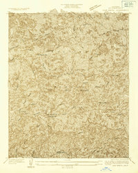
1934 Map of Camp Bonita
USGS Topo · Published 1934About this map
The Angeles National Forest San Gabriel Mountains dominate this 1934 topographic study, revealing a landscape defined by extreme relief and early mountain industry. Miners and ranchers carved out a precarious existence along the steep drainage basins, leaving behind sites like the Stanley Miller Mine, Allison Mine, and Baldora Mine. These mining operations are situated near prominent peaks such as Rattlesnake Peak and Iron Mtn, highlighting the intersection of geological exploration and industrial ambition in the high country.
Find a feature on this map
29 named features on this map. Tap any name to fly to it.
Don’t see what you’re looking for? This feature index may not catch every label — zoom into the map to look around manually.
Map Details
Editions of this 1934 Camp Bonita Map
This is the sole edition of this map. No revisions or reprints were ever made.
Other maps of this area

1894 · Pomona
USGS Topo · 1:62,500

1897 · Pomona
USGS Topo · 1:62,500

1897 · Cucamonga
USGS Topo · 1:62,500

1898 · Pomona
USGS Topo · 1:62,500

1900 · Cucamonga
USGS Topo · 1:62,500

1901 · Southern California Sheet No. 1
USGS Topo · 1:250,000

1903 · Rock Creek
USGS Topo · 1:62,500

1903 · Cucamonga
USGS Topo · 1:62,500

1903 · San Antonio
USGS Topo · 1:62,500

1904 · Pomona
USGS Topo · 1:62,500