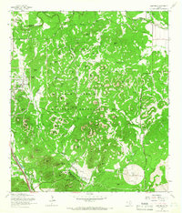
1965 Map of Camp Bullis
USGS Topo · Published 1966About this map
The Leon Springs Military Reservation dominates the landscape of northern Bexar County in the mid-1960s, showcasing a dense network of military infrastructure and training grounds. Established installations at Camp Stanley and Camp Bullis are connected by the Government Railroad and a series of rugged paths like the Bullis Wilderness Road and Eagles Nest Trail. The terrain is characterized by dozens of named summits, including High Hill and the distinctive Mont Blanc, which overlook the winding courses of Cibolo Creek and Salado Creek. Genealogy and local history researchers can locate specific landmarks such as the Goforth Cem and various family-named features like Schasse Hill and Hue Hill. The presence of Observation Towers, Radio Towers, and a Landing Strip illustrates the tactical training utility of this Texas Hill Country terrain during the Cold War era.
Find a feature on this map
87 named features on this map. Tap any name to fly to it.
Don’t see what you’re looking for? This feature index may not catch every label — zoom into the map to look around manually.
Map Details
Editions of this 1965 Camp Bullis Map
2 editions found
Other maps of this area

1920 · Smithsons Valley
USGS Topo · 1:62,500

1927 · Smithson Valley
USGS Topo · 1:62,500

1929 · Smithson Valley
USGS Topo · 1:62,500

1940 · Smithson Valley
USGS Topo · 1:62,500

1953 · Otis Ridge
USGS Topo · 1:24,000

1953 · Bulverde
USGS Topo · 1:24,000

1953 · Longhorn
USGS Topo · 1:24,000

1953 · Helotes
USGS Topo · 1:24,000

1953 · Castle Hills
USGS Topo · 1:24,000

1953 · Van Raub
USGS Topo · 1:24,000