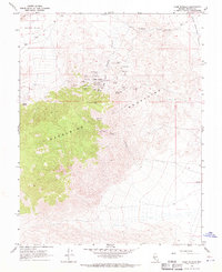
1967 Map of Camp Douglas
USGS Topo · Published 1970About this map
Camp Douglas sits at the heart of an intensive mining district in Mineral County during the late 1960s. This survey reveals a landscape transformed by extraction, with dozens of named claims and workings clustered in the hills north of Thunder Mtn. The concentration of sites such as the Maryann Mine, 1905 Mine, and Orphan Boy Mine suggests a period of sustained activity in these high basins.
Find a feature on this map
35 named features on this map. Tap any name to fly to it.
Don’t see what you’re looking for? This feature index may not catch every label — zoom into the map to look around manually.
Map Details
Editions of this 1967 Camp Douglas Map
2 editions found
Other maps of this area

1909 · Hawthorne
USGS Topo · 1:250,000

1911 · Hawthorne
USGS Topo · 1:250,000

1915 · Hawthorne
USGS Topo · 1:250,000

1948 · Walker Lake
USGS Topo · 1:250,000

1957 · Walker Lake
USGS Topo · 1:250,000

1962 · Walker Lake
USGS Topo · 1:250,000

1964 · Walker Lake
USGS Topo · 1:250,000

1967 · Moho Mountain
USGS Topo · 1:24,000
1967 · Candelaria
USGS Topo · 1:24,000

1967 · Mina NW
USGS Topo · 1:24,000