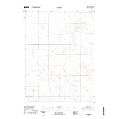
2017 Map of Camp Lake
USGS Topo · Published 2017About this map
Camp Lake and Peterson Lake are the defining water features of this Morrill County landscape, located within the Nebraska Sandhills. The terrain is characterized by a high density of small depressions and seasonal wetlands typical of the region's unique geography. High points such as Reilly Hill provide relief amidst the undulating dunes and interdunal valleys. A network of county and local roads, including Co Rd 111 and Rd 114, bisects the area, following the section lines established by the Public Land Survey System. These routes facilitate movement across the cattle ranching country that occupies much of the quadrangle. The sparse distribution of man-made structures on this 2017 survey reflects the low population density of the Nebraska panhandle, where land use is primarily dedicated to large-scale ranching operations centered around the available water sources in the valley floors.
Find a feature on this map
16 named features on this map. Tap any name to fly to it.
Don’t see what you’re looking for? This feature index may not catch every label — zoom into the map to look around manually.
Map Details
Editions of this 2017 Camp Lake Map
This is the sole edition of this map. No revisions or reprints were ever made.
Other maps of this area

1896 · Browns Creek
USGS Topo · 1:125,000

1898 · Camp Clarke
USGS Topo · 1:125,000

1899 · Browns Creek
USGS Topo · 1:125,000

1949 · Lynn
USGS Topo · 1:62,500

1954 · Scottsbluff
USGS Topo · 1:250,000

1958 · Scottsbluff
USGS Topo · 1:250,000

1965 · Angora SE
USGS Topo · 1:24,000

1965 · Broadwater NW
USGS Topo · 1:24,000
1965 · Angora NE
USGS Topo · 1:24,000
1965 · Bridgeport
USGS Topo · 1:24,000