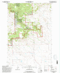
1993 Map of Camp Needmore
USGS Topo · Published 1996About this map
Custer National Forest anchors this southeastern Montana landscape, where the public lands of the National Forest Boundary meet the open range of Carter County. The geography is defined by a network of drainage systems including Little Ramme Creek and Big Ramme Creek, which flow southward away from the prominent heights of Conger Hill and Murphy Hill. This 1990s-era survey reveals a pastoral economy still very much active, marked by isolated homesteads and family holdings such as the Burch Ranch, L Carroll Ranch, and B McCabe Ranch. At the heart of the forest land lies Camp Needmore, a central node in an area characterized by scattered springs like Heggen Spring and Oliver Springs that sustained both livestock and local inhabitants. The presence of a Rodeo Ground and a Radio Tower underscores the intersection of traditional western culture and modern infrastructure in this expansive high-plains environment.
Find a feature on this map
27 named features on this map. Tap any name to fly to it.
Don’t see what you’re looking for? This feature index may not catch every label — zoom into the map to look around manually.
Map Details
Editions of this 1993 Camp Needmore Map
This is the sole edition of this map. No revisions or reprints were ever made.
Other maps of this area

1954 · Ekalaka
USGS Topo · 1:250,000

1956 · Ekalaka
USGS Topo · 1:250,000

1958 · Ekalaka
USGS Topo · 1:250,000

1965 · Ekalaka
USGS Topo · 1:250,000

1979 · Dead Boy Divide
USGS Topo · 1:24,000

1979 · Ekalaka
USGS Topo · 1:24,000

1980 · Taylor Hills
USGS Topo · 1:24,000

1980 · Belltower
USGS Topo · 1:24,000

1980 · Camp Needmore
USGS Topo · 1:24,000

1980 · Dutchmans Hill
USGS Topo · 1:24,000