
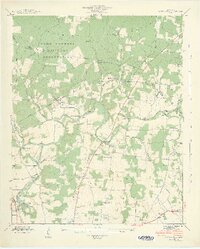
1936 Map of Camp Peay
USGS Topo · Published 1936About this map
Camp Peay and the National Guard Reservation occupy the highlands east of Tullahoma in this 1936 survey. The landscape is defined by the strategic intersection of the Nashville Chattanooga and St Louis Ry and a network of transmission lines, including the Ovoca Transmission Line and the Tennessee Electric Power Company Transmission Line. This era represents a period of significant regional development, marked by the presence of infrastructure like the Boyd Airport and the Girls Vocational Sch at Elsie. To the southeast, Estill Springs sits near the Elk River, while the surrounding countryside is dotted with small community landmarks like Rock Creek Ch, Pleasant Grove Ch, and the Unity Sch. The map reveals a transitioning rural economy, where traditional family cemeteries like Holt Cem and Gault Cem stand alongside the growing industrial and military footprint of the Tennessee Valley.
Find a feature on this map
62 named features on this map. Tap any name to fly to it.
Don’t see what you’re looking for? This feature index may not catch every label — zoom into the map to look around manually.
Map Details
Editions of this 1936 Camp Peay Map
This is the sole edition of this map. No revisions or reprints were ever made.
Other maps of this area

1928 · Decherd
USGS Topo · 1:62,500

1936 · Ovoca
USGS Topo · 1:24,000

1936 · Manchester
USGS Topo · 1:24,000

1936 · Cumberland Springs
USGS Topo · 1:24,000

1936 · Winchester
USGS Topo · 1:24,000

1936 · Belvidere
USGS Topo · 1:24,000

1936 · Capitol Hill
USGS Topo · 1:24,000

1936 · Normandy
USGS Topo · 1:24,000

1936 · Lois
USGS Topo · 1:24,000
1941 · Capitol Hill
USGS Topo · 1:24,000