
1928 Map of Decherd
USGS Topo · Published 1928About this map
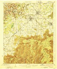
Winchester and Decherd serve as the primary hubs of this 1920s Franklin County landscape, where the Nashville Chattanooga and St Louis Railway dictates the pace of commerce and travel. The geography is defined by the sharp contrast between the fertile valley floor and the rising Cumberland Mountains to the southeast. Settlers and farmers in the late 1920s relied on a dense network of local institutions, including Keith Springs Ch, Mingo Sch, and Oak Grove Sch, which are scattered throughout the coves and gaps. Significant water features like the Elk River and Riva Lake frame the northern reaches, while the terrain becomes increasingly complex near Flat Top and Grassy Glade Ridge. This map captures a rural Tennessee society organized around family-named hollows and small rail stops like Belvidere and Cowan just before modern infrastructure reshaped the valley.
Find a feature on this map
77 named features on this map. Tap any name to fly to it.
Don’t see what you’re looking for? This feature index may not catch every label — zoom into the map to look around manually.
Map Details
Editions of this 1928 Decherd Map
3 editions found
Other maps of this area

1886 · Stevenson
USGS Topo · 1:125,000

1888 · Scottsboro
USGS Topo · 1:125,000

1892 · Scottsboro
USGS Topo · 1:125,000

1892 · Stevenson
USGS Topo · 1:125,000

1895 · Stevenson
USGS Topo · 1:125,000

1895 · Sewanee
USGS Topo · 1:125,000

1936 · King Cove
USGS Topo · 1:24,000

1936 · Sewanee
USGS Topo · 1:24,000

1936 · Alto
USGS Topo · 1:24,000

1936 · Sinking Cove
USGS Topo · 1:24,000