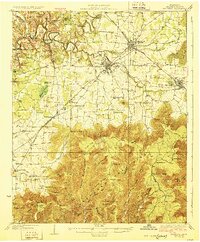
1928 Map of Decherd
USGS Topo · Published 1928About this map
The Elk River winds through the northern reaches of this landscape, its path marked by unique geographic features like The Loop and Riva Lake. To the south, the topography shifts dramatically as the terrain rises into the Cumberland Mountains, defined by a series of deep coves such as Williams Cove and Binghams Cove. This era is characterized by a dense network of rural infrastructure, where numerous small schools like Peabody Sch and Little Hurricane Sch served isolated communities. The corridor of the Nashville Chattanooga and St Louis Railway serves as the primary industrial artery, connecting the established hubs of Winchester, Decherd, and Cowan. Notable family and community landmarks, including Faris Chapel and Goshen Ch, appear alongside local transport points like the Willis Lake Bridge, reflecting a transition from river-bottom farming to mountain-edge settlement.
Find a feature on this map
78 named features on this map. Tap any name to fly to it.
Don’t see what you’re looking for? This feature index may not catch every label — zoom into the map to look around manually.
Map Details
Editions of this 1928 Decherd Map
3 editions found
Other maps of this area

1886 · Stevenson
USGS Topo · 1:125,000

1888 · Scottsboro
USGS Topo · 1:125,000

1892 · Scottsboro
USGS Topo · 1:125,000

1892 · Stevenson
USGS Topo · 1:125,000

1895 · Stevenson
USGS Topo · 1:125,000

1895 · Sewanee
USGS Topo · 1:125,000

1928 · Decherd
USGS Topo · 1:62,500

1936 · King Cove
USGS Topo · 1:24,000

1936 · Sewanee
USGS Topo · 1:24,000

1936 · Alto
USGS Topo · 1:24,000