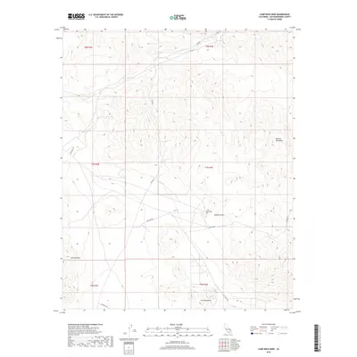
2018 Map of Camp Rock Mine
USGS Topo · Published 2018About this map
The Camp Rock Mine sits at the heart of this high-desert landscape in the Mojave Desert, serving as a central landmark for this arid region. The topography is dominated by the northern reaches of the Fry Mountains and the western slopes of the Rodman Mountains, with East Ord Mtn rising to the southwest. Water resources, though sparse, are marked by the seasonal drainage of Kane Wash and the presence of Kane Springs in the northern portion of the quadrangle. This 2018 survey illustrates the network of desert tracks and primary access routes like Camp Rock Rd and Troy Rd, which navigate the complex elevation changes between the mountain peaks and the broad valley floors. The map provides a detailed view of the terrain used for mineral extraction and off-road navigation in the eastern California desert.
Find a feature on this map
16 named features on this map. Tap any name to fly to it.
Don’t see what you’re looking for? This feature index may not catch every label — zoom into the map to look around manually.
Map Details
Editions of this 2018 Camp Rock Mine Map
This is the sole edition of this map. No revisions or reprints were ever made.
Other maps of this area

1953 · San Bernardino
USGS Topo · 1:250,000

1955 · Silver Bell Mine
USGS Topo · 1:24,000

1955 · Newberry
USGS Topo · 1:62,500

1955 · Ord Mountains
USGS Topo · 1:62,500

1955 · Rodman Mountains
USGS Topo · 1:62,500

1956 · San Bernardino
USGS Topo · 1:250,000

1956 · Daggett
USGS Topo · 1:62,500

1957 · San Bernardino
USGS Topo · 1:250,000

1958 · San Bernardino
USGS Topo · 1:250,000

1959 · San Bernardino
USGS Topo · 1:250,000